File:Niuafoʻou before 1943 eruption.jpg
Jump to navigation
Jump to search

Size of this preview: 456 × 599 pixels. Other resolutions: 183 × 240 pixels | 365 × 480 pixels | 640 × 841 pixels.
Original file (640 × 841 pixels, file size: 168 KB, MIME type: image/jpeg)
Captions
Captions
Add a one-line explanation of what this file represents
Summary
[edit]
| Description |
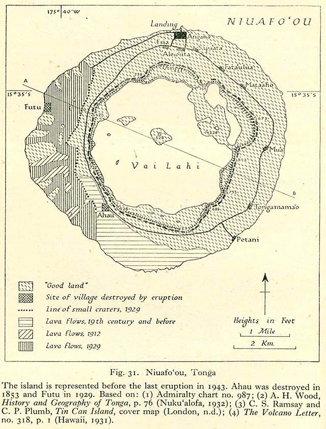
English: Map of Niuafoʻou before the 1943 eruption, showing lava flows and villages of the island.
Text : "The island is represented before the last eruption in 1943. Ahau was destroyed in 1853 and Futu in 1929. Based on:(1) Admiralty chart no. 987 ; (2) A. H. Wood, History and Geography of Tonga, p76 (Nuku'alofa, 1932) ; (3) C.S. Ramsay and C.P. Plumb, Tin Can Island, cover map (London, n.d.) ; (4) The Volcano Letter, no. 318, p.1 (Hawaii, 1931)
Français : Carte de l'île de Niuafoʻou avant l'éruption de 1943, montrant les différentes coulées de lave et les villages de l'île. |
| Date | |
| Source | http://www.lib.utexas.edu/maps/historical/pacific_islands_1943_1945/niuafoou_tonga.jpg Geographical Handbook Series, Great Britain. Admiralty. Naval Intelligence Division, 1943-1945 - Volume III : Western Pacific (Tonga to Solomon Islands), 1944. |
| Author | Admiralty. Naval Intelligence Division. |
Licensing
[edit]
This work created by the United Kingdom Government is in the public domain.
This is because it is one of the following:
HMSO has declared that the expiry of Crown Copyrights applies worldwide (ref: HMSO Email Reply)
|
 |

|
This image has been assessed under the valued image criteria and is considered the most valued image on Commons within the scope: Map of Niuafo'ou before 1943 eruption. You can see its nomination here. |
File history
Click on a date/time to view the file as it appeared at that time.
| Date/Time | Thumbnail | Dimensions | User | Comment | |
|---|---|---|---|---|---|
| current | 13:51, 30 November 2015 | | 640 × 841 (168 KB) | Skimel (talk | contribs) | User created page with UploadWizard |
You cannot overwrite this file.
File usage on Commons
The following 3 pages use this file:
File usage on other wikis
The following other wikis use this file:
- Usage on fr.wikipedia.org